Project pathway
The quickest route to the right decision.

Do you need explosive ordnance information or an investigation commission for your property in Ostwestfalen-Lippe? First clarify which documents must be requested through the municipality and which additional specialist service you need. FONTANA-EOD supports preparation and execution of the specifically agreed investigation commission.
Start with the responsible municipality.
Define the service and investigation area.
Pass results to the parties involved.
For construction projects in the Detmold administrative district, the municipal enquiry and private specialist service refer to the same plans. We assess the available information together with the proposed groundworks. Responsibilities, investigation scope and complete handover of results remain traceable for everyone involved and clearly allocated throughout the subsequent process.
Documented location references
Select a project location on the map or in the location list. The associated entries lead to the protected reference overview.
The points indicate place references of documented projects, not precise ordnance find or construction site coordinates. Several entries may belong to one project. References without a reliable place assignment are available in the complete reference overview.
Map bases: © BKG (2026), VG250 / GN250, Data licence Germany – attribution 2.0. Area outline projected for display. Selection and project assignment: FONTANA-EOD.
Service period: 2024-10
Service areas:Ordnance specialist supervision of groundworksSurface surveys: GPR, TDEM and magnetometryMethod used in this project: Ground-penetrating radar
View project details · GPR and limitations · Ordnance specialist supervision of groundworks
Service period: 2025-06
Service areas:Ordnance specialist supervision of groundworks
View project details · Ordnance specialist supervision of groundworks
Service period: 2025-05
Service areas:Ordnance specialist supervision of groundworks
View project details · Ordnance specialist supervision of groundworks

For questions about a specific explosive ordnance procedure, the Lippe district directs enquiries to the responsible office of the relevant municipality, usually the local Ordnungsamt. State aerial photograph analysis is undertaken by the Westfalen-Lippe explosive ordnance disposal service at the Arnsberg district government. Only local regulatory authorities are authorised to submit applications. The municipal procedure and supplementary specialist commission are therefore clearly related to one another for the project. The Detmold administrative district forms the administrative area of Ostwestfalen-Lippe in North Rhine-Westphalia. Regional planning coordinates land-use interests here, including housing, commercial development, transport and energy. For a specific project, the municipality and subareas concerned are identified. Where there are several project locations, local procedures remain traceable with their respective plans and responses. Besides Detmold, the KBD Westfalen-Lippe also serves the Arnsberg and Münster administrative districts.
Information on explosive ordnance surveying in Bielefeld, Paderborn, Gütersloh, Minden, Herford, Bad Oeynhausen and Detmold helps you prepare your project enquiry. The documents and proposed ground interventions on the particular property are decisive.
The Detmold district government describes its regional remit as Ostwestfalen-Lippe. State wartime aerial photograph analysis for this administrative district is undertaken by the Westfalen-Lippe explosive ordnance disposal service at the Arnsberg district government. For construction projects in the Lippe district, the district explicitly identifies the responsible office of the relevant municipality as the first contact in a specific procedure. The state service supplies the local regulatory authority with its analysis findings and a recommendation for action. For further planning, these documents are assigned to the actual area and the subject of the enquiry at that time. Subsequent plan updates have an identifiable revision so that existing information can be taken into account specifically.
The Bielefeld City Archives document the air raid of 30 September 1944 as a local event of the Second World War. For a project in the administrative district, documented local events are related to former property use and the historical documents available for the specific area. The regional context thus leads to a focused research question; project assessment relies on the area-specific findings actually available.
Local regulatory authorities submit applications for state aerial photograph analysis. A private specialist commission must be distinguished from this. It may concern, for example, preparation of existing documents or a coordinated technical investigation. To align both strands of work, the property, project and responses already available must be identified clearly. For a supplementary specialist service, it is established which construction section is to be addressed and who supplies access, construction dates and existing utility information. Municipal responses already issued are attached with their appendices. Before the next intervention, the parties can thus coordinate the preparation still outstanding and the clarified task to which the specialist commission relates.
For the commissioned activities, the relevant technical requirements and questions of permits, competence certification and responsibility are clarified. The actual planned service scope is decisive. A general company designation does not replace checking that the tasks and interfaces are described appropriately for the specific project.
Risk assessment, work areas and communication must suit the proposed activities. Ordnance specialist works are coordinated with the other construction activities. Operational organisation, traffic safety and other specialist technical inspections retain their own responsible parties. Joint coordination brings the information together without equating the different tasks.
A measurement anomaly first requires specialist assessment; its appearance alone does not identify it as explosive ordnance. If an object is genuinely suspected to be ordnance, the prescribed reporting procedures and the measures set by the responsible authorities apply. Investigation reports specify the work completed and its limitations, so that results are not extended to unexamined areas or later design changes.
Procedure at the site: Detmold district government: Regional planning in Ostwestfalen-Lippe · Lippe district: Explosive ordnance detection and aerial photograph analysis · Arnsberg district government: Wartime aerial photograph analysis for explosive ordnance detection · Arnsberg district government: Westfalen-Lippe explosive ordnance disposal service.
Planning and documentation: BFR KMR: principles of clearance planning · BFR KMR: geophysics · BFR KMR: documentation
The BFR KMR are used as technical guidance; locally applicable requirements and responsibilities must be clarified separately.
The permit, qualifications and responsibilities for the specific activity are assessed under the Explosives Act and the First Ordinance to the Explosives Act. The risk assessment under Section 5 of the Occupational Safety and Health Act relates to the planned activities. The DGUV Information 201-027 addresses preventive investigation and clearance of conventional explosive ordnance and defines its scope. The references it explains to DGUV Regel 113-003 concern specific activities involving explosives; they are not applied indiscriminately to every construction investigation.
For private activities in North Rhine-Westphalia, the specific requirements of the exceptions under the KampfmittelVO and the official guidance must be observed. Technical suitability alone does not establish that a private commission is permissible. The information held by the authorities and the authorisations required for the activity are checked before an agreement is made.
The client describes the project and provides the existing project documents. The operator adds the requirements for use, access and timing. A coordinating contact agrees the assigned tasks with those responsible. Before commissioning, a clear record is made of which information is missing, who will obtain it and which decision the results are intended to inform.
The specialist designers describe areas, depths, construction methods and changes. Site management coordinates the planned sequence with the construction contractors and agreed specialist works. Results are assigned to the respective intervention. A technical plan change is communicated early enough for its effect on the survey task to be assessed before construction. Organisational construction stage boundaries remain distinguishable from technical survey boundaries.
The private explosive ordnance specialist carries out the agreed investigation and documentation scope. Official requirements and decisions are clarified with the competent authorities concerned. The documents needed for a particular procedure depend on the location and project. The technical report describes the specialist service performed; its conclusions are not presented unchecked as general authorisation for further groundworks or as an authority's decision.
The specific content of available assessments is first compared with the proposed interventions. A missing appendix or unclear area boundary is identified. The appropriate further investigation follows the findings actually required. Being located in Ostwestfalen-Lippe alone does not establish a uniform procedure for every property and construction task.
Assess historical documentsThe agreed specialist service identifies the tasks that may be addressed privately and their necessary prerequisites. Responsibilities and permissions required are checked beforehand. Commissioning FONTANA-EOD does not replace a state application. Existing results are used on technical grounds insofar as their findings fit the current area and proposed intervention.
Compare investigation methods
Link both procedures to the same property location and an identifiable plan revision. Different file references or processing routes must not obscure the spatial allocation. The groundworks concerned remain clear for follow-up questions. A private investigation commission and a municipal enquiry may serve different purposes but must be based on traceable information.
Coordinate the sequence and tasksIf a construction area is enlarged or a foundation changed, it is assessed which ongoing procedures are affected. The revised plans receive a clearly identified version. The local office can then relate its response to them and specialist planners can check their commission. A change circulated only internally may otherwise be overlooked in the existing procedure.
Coordinate the sequence and tasksNot all appendices to earlier information are always available. Describe which documents exist and which are missing. Questions about results are distinguished from questions about the official original image collection. For the current commission, the decisive issue is which usable findings are obtainable for the construction area concerned and what spatial scope they can be assigned.
Document findings and their limitationsThe following specialist topics explain possible investigation tasks. Which activity may be privately commissioned under the specific North Rhine-Westphalia procedure is clarified separately before an agreement.
The commission clearly identifies the municipal procedure and the additional private specialist task required. Existing information, appendices and result reports are related to the actual construction area. The proposed groundworks are assigned a location, depth and construction method. This allows it to be established whether documents need preparation, further ground volumes need technical investigation or assessed findings need permissible further work. The commissioned service and required results are assigned this scope. The private commission does not replace the local regulatory authority's entitlement to apply for state aerial photograph analysis.
Define the specialist taskBefore work is carried out, actual survey access, utility information and interfaces with other trades are clarified. Responsible contacts keep the agreed prerequisites associated with the specialist commission. Preparatory work required depends on the method and site. Additional opening-up work or other interventions to create investigation access are prepared by specialists and are not undertaken independently. Municipal responses are considered with their appendices. Missing documents or prerequisites remain assigned to the area concerned so that deployment coordination and the official procedure refer to the same plan revision.
Clarify preparatory work in the programmeThe commission identifies the permissible private specialist service and the results required from it. Assessment and handover of results are part of the process. Effort and dates depend on actual access, documents and coordination. The existing municipal procedure is considered with its work status; it is not recorded as complete solely because a private contract has been concluded. If the construction task or documents required change, the respective parties are involved with a traceable revision. Commissioning and further coordination retain their different functions.
Discuss the scope and scheduleState which municipality the area is in and attach a site plan. Add available cadastral parcel details and mark the proposed intervention area. A regional description such as Ostwestfalen-Lippe is not sufficient for allocation. The local office can tell you which specific documents and information its procedure requires. For a route crossing several properties, the plan shows which sections belong to the same enquiry. Record existing file references and dated plans against the subareas concerned. This enables the local office and specialist planners to ask focused questions about the intended section. A change in the next construction section thus remains distinguishable from the status of the area already assessed.
Describe whether, for example, a building is to be extended, a utility installed or an excavation pit formed. Include location, depth and working method insofar as established. Distinguish existing structures from new works on the drawing. It can then be checked whether an existing assessment concerns the project or considered other areas and depths. For an excavation pit, for example, the foundation area, proposed shafts and lateral utility connections are shown separately. An axis moved subsequently receives an identifiable revision. The specialist bodies involved can then identify the new subarea that needs assessment and the earlier information that still describes the same intervention.
Compile existing official information and specialist reports with their appendices. An older letter should still show which enquiry it answered. Tell the parties involved if documents are missing. A recollection that the area was assessed at some point does not replace traceable original findings. The overview identifies the date, commission and associated plan appendices for each document. An earlier assessment of another structural element is not allocated solely through a shared address. Specialist planners compare the ground volume actually addressed with the new works and record which findings can be used for the next decision.
If planning, ownership and site management are handled by different parties, specialist correspondence should nevertheless be brought together. Identify who supplies further documents and passes on plan changes. This organisational contact does not take on official responsibilities; they ensure that proposed works and answered questions remain aligned. For coordinated processing, it is established who brings current plans and new responses together in the project file. When project management changes, documents are handed over with their work status, outstanding questions and information still needed. The new contact can then ask focused questions about the construction section concerned and allocate necessary additions to the responsible parties.
Documents are kept with their respective purpose and plan reference. A specialist investigation adds to existing knowledge within the agreed scope. It does not automatically replace a municipal procedural step. When information is passed on, the original official information, associated maps and new results therefore remain distinguishable without separating important conditions from their shared context. For completed clearance work, the clearance record is allocated separately with its actual clearance scope and results; its link to the area addressed and the relevant site plan is retained. For each construction section, the handover identifies the plans used and the findings associated spatially with them. Site management receives the limitations affecting its immediately approaching works. Outstanding conditions are recorded together with the responsible party and the next step required. This status is passed on in full if the contractor changes.
The next planning or construction phase receives results including their appendices and limitations. Outstanding questions remain identifiable as such. Any response required to the local office is clarified in the respective procedure. A short note about a completed appointment describes neither the investigated area nor the full scope of the report's findings. A deeper foundation may raise different questions from a simple shift on the site plan. Therefore identify the changed geometry and documents concerned in each case. The responsible parties assess the change within their specialist remit and bring their results together with the current design. An earlier quotation is related to its actually agreed scope.
Present the location, current plan and proposed measure clearly. Existing information is attached and missing information identified. The local office can explain the specific procedure. At the same time, this establishes an organised basis for subsequent specialist coordination without predetermining a particular investigation scope. For the service specification, preparation, possible investigation, interpretation and handover are clearly distinguished. Identify who provides access, utility information and existing reports. Outstanding responses are also identified with their actual work status. The enquiry can thus focus on the outstanding specialist task and proposed construction section.
Read the response together with the submitted plan and the groundworks established since then. Pass on identifiable differences. The private commission incorporates the applicable conditions and describes its own task. After work is carried out, results are handed over in full to the intended parties, and outstanding subareas are carried forward in planning. Before work resumes, the plan and report versions are checked together. A new site organisation receives the information relevant to its task on investigated, uninvestigated and partially assessable areas. The handover note identifies outstanding questions and the body with which further work is coordinated.
Historical aerial photograph analysis and other earlier records help establish the spatial basis of a suspected hazard. Images, interpretive capability and area boundaries are related to the proposed groundworks. An absence of visible findings is not a technical investigation of the present-day ground. Other existing knowledge is incorporated. A state assessment with its appendices is assigned to the municipal procedure and actual area. Historical information additionally prepared privately receives its own purpose and status. Further specialist work retains a clear indication of the basis of each finding.
Understand aerial photograph assessmentMagnetometric methods detect magnetic anomalies. Suitability is assessed in relation to expected objects, ground conditions, interference and the ground volume requiring investigation. Utilities, fences and existing structures can affect interpretation. Signal strength alone does not identify explosive ordnance. Surveying, assessment and further clarification are linked to the specific specialist task. The private investigation commission describes the ground volume actually required and the result documents expected. Existing official information is considered according to its findings rather than treated as a survey already carried out.
Understand the scope of magnetometryElectromagnetic investigations may be suitable for certain metallic target objects and site conditions. Selection considers the findings required, accessible survey areas and interfering installations, rather than equipment availability alone. Results are documented with their location and actual investigation conditions. Additional work required follows from specialist assessment. Selection is linked to existing responses and the permissible commissioned scope. A specialist commission described in general terms does not, by itself, establish a suitable method for every work area.
Understand electromagnetic surveyingUnder suitable conditions, ground-penetrating radar can provide information about subsurface structures and reflections. Ground conditions, moisture and installations affect interpretability. A reflection is not automatically explosive ordnance; an area without anomalies does not confirm any arbitrary depth. Specialist interpretation and limitations are documented with the commission. An existing radar report is read according to its purpose and coverage. Its findings are assigned to the private specialist commission and current construction task rather than used unchecked as a complete answer to the municipal procedure.
GPR and limitationsFor deeper interventions, it may be necessary to assess whether investigation from the surface can provide the findings required or whether another approach is needed. Positions, depths, reference elevations, borehole layouts and known utilities are prepared for this purpose. Creation of suitable investigation access is also planned by specialists. A standard grid or general depth figure does not replace this task. The precise specialist task is checked against existing responses and current construction plans. A municipal file reference alone describes neither the technical method nor the depth interval requiring investigation.
Prepare deep interventionsIf a necessary advance investigation cannot be completed in full, it is assessed whether a specialist-planned approach accompanying construction is suitable. Investigation, interpretation and communication of findings are linked to the groundworks actually proposed. Visual observation of excavated material alone does not replace a necessary survey. Site management receives the allocation of specialist work and outstanding areas to the work sequence. The permissible private service scope and coordination required are recorded specifically. Supervision is not assumed to have been commissioned or completed solely because a municipal procedure exists.
Agree the approach during constructionThe historical aerial photograph analysis by the state service is arranged through the local regulatory authority. Existing results and their spatial reference are decisive for further specialist planning. Ask about the information and appendices available within the specific procedure. A private commission to FONTANA-EOD does not replace this official application route.
The Arnsberg district government explains that wartime aerial photographs held by its explosive ordnance disposal service are neither supplied to third parties nor available there for inspection. This restriction concerns that official image collection. It must not be confused with the question of which result documents exist for your construction project and how you can obtain them.
A survey must be planned on the basis of existing knowledge, the intervention and survey conditions. Discuss which areas and depths are to be considered and which prerequisites are present on site. If existing documents leave a question unanswered, it must first be identified. Without further assessment, this does not mean that every property in the region requires the same investigation.
Compare the information received with the enquiry and the plans submitted at that time. Does it concern the required area and the correct project? Indicate if the plans have since changed. A formally matching address is not enough to equate different construction areas or intervention depths. Initial contact identifies the project address, proposed works and current plan revision. Specialist planners check existing explosive ordnance reports for their area and depth references, limits of findings and identifiable gaps. They assign official indications and investigations already carried out to their respective functions. The document overview shows which results are usable for the new construction task and which question still needs an answer.
Existing aerial imagery analyses and historical indications are related to the present-day project area. Where the basis is incomplete, the necessary supplementary research or aerial imagery analysis is carried out through the appropriate specialist or official route with its question defined. The findings obtained are assessed together with previous use and current plans to determine investigation needs. An entry in the town's history is first checked for its actual relevance to the property.
If the documents establish prerequisites for further work, these should be identifiable when the service is agreed. Also describe earlier work already available and who still needs to supply information. The commission should continue the clarification already achieved. It should neither pre-empt an unknown official decision nor silently extend existing evidence. Investigation planning selects suitable methods according to the findings required, intervention depth and actual site conditions. Existing utilities, installations and interference are taken into account. The commission describes its spatial scope and the prerequisites for its execution. The area drawn remains linked to the specific construction task if the foundation or utility route changes.
Before groundworks begin in a subarea whose status remains unresolved, the specialist clarification required for it must take place. Where a clearance plan is proposed, it describes the necessary steps and their sequence. The parties should know which documents must be available before each work step and how construction changes are communicated. On this clarified basis, specialist personnel carry out the investigation or agreed supervision permitted within the relevant legal and technical scope. Data are recorded with spatial reference, site survey conditions and limitations. If conditions change, the further approach is coordinated. A suspicious find triggers the prescribed reporting and hazard-prevention procedures.
The data and findings collected are professionally assessed in the context of the investigation objective, method and site conditions. Interference and areas that cannot be investigated remain identifiable. The report documents the work carried out, results, location and depth references, and limitations; maps and attachments remain connected to it. Any further clarification required is assigned to the affected area. A measurement anomaly is professionally assessed and is not identified as a particular object solely on the basis of the measurement signal.
Pass the investigation report with plans and limitations to the intended parties. A short message stating that the appointment took place does not yet describe its result. Identify whether subareas remain outstanding or plans need adjustment. Clarify in the respective procedure which further response the local office needs. The assessed report and associated plans are handed over together for the next construction phase. Site management compares its approaching works with the investigated area and documented limitations. Outstanding tasks are assigned a responsible contact and a reference to the next intervention. The plan and report revisions used remain traceable for later additions.
Keep the municipal enquiry, information received and results of commissioned specialist work together. Each document should be assignable to its plan revision and work area. This preserves a clear record of which questions have been answered and which must be reconsidered before revised construction work.
FONTANA-EOD's specialist service follows the agreed commission. Local hazard prevention and state tasks remain with the competent authorities. The BFR Kampfmittelräumung are directly directed at federal properties; for other projects, they can contribute technically to planning and documentation without replacing coordination of the local procedure.
FONTANA-EOD addresses the agreed private specialist task for the defined work area in Ostwestfalen-Lippe. Before work begins, existing information and results required are related to the same plan revision. Accessible areas and prerequisites are coordinated. Changes to plans or site conditions are checked before the work concerned. The report documents the work actually carried out and its limitations. Site management can traceably bring together the municipal procedure's status and the private specialist services actually provided, with their respective findings.
Discuss the investigation taskMethod selection starts with the knowledge lacking for the current construction task. Specialist planning considers existing results, the ground and actual conditions. Available equipment or the mere award of a private commission does not suffice as the sole basis. Selection is justified for the ground volume concerned. Existing official indications are considered with their appendices. The specific technical task remains identifiable even when several bodies are involved in preparation and further coordination.
Inaccessible areas and areas with limited interpretability are identified with their actual boundaries. Site management can allocate outstanding specialist work and necessary additions to them. A general overall area figure does not replace this distinction. Planning and construction teams coordinate when a suitable investigation will be possible. Missing findings remain identifiable when passed to other parties. Completion of a private partial commission is not passed on as a comprehensive official assessment or complete treatment of the property.
A new location, additional depth or different construction method is compared with existing results before the work concerned. Specialist planners receive the identifiable change from the previous status. Their response and necessary additions are assigned to the ground volume concerned. Project organisation also carries the revised plans into the coordination affected. An unchanged municipal file reference or continued order number does not, by itself, confirm unchanged technical scope.
At handover, reports and associated plan appendices are supplied with the area, specialist task and work status identified. An overview may list municipal responses and results of private specialist work with their respective findings. It does not replace the documented investigation scope. When designers, site management or companies change, complete appendices and outstanding tasks remain accessible. The next parties receive the information for their own work step without inferring completion of all other work from a single procedure.
The rules on access to the wartime aerial photograph collection held by the state service concern those original images. Availability of information or a result report for the project must be clarified separately. A missing image copy therefore does not automatically mean that no usable result document exists. Specialist planning depends on its complete content with the specific spatial reference.
Understand investigation reports and their limitationsIf owners, designers and site management work separately, a named person helps with questions and plan changes. They bring documents together and maintain a traceable status. This does not create additional official powers. Specialist tasks and local procedural steps remain with the parties responsible for them.
Understand the service scope
Aerial photograph interpretation is related to the actual groundworks. Its purpose and geographical scope remain distinct from a technical investigation of the ground as it is today.
Understand aerial photograph assessmentThe findings, their locations and limitations are handed over together. This makes clear to those carrying out the work which area has been investigated and which task remains outstanding.
Assess investigation reports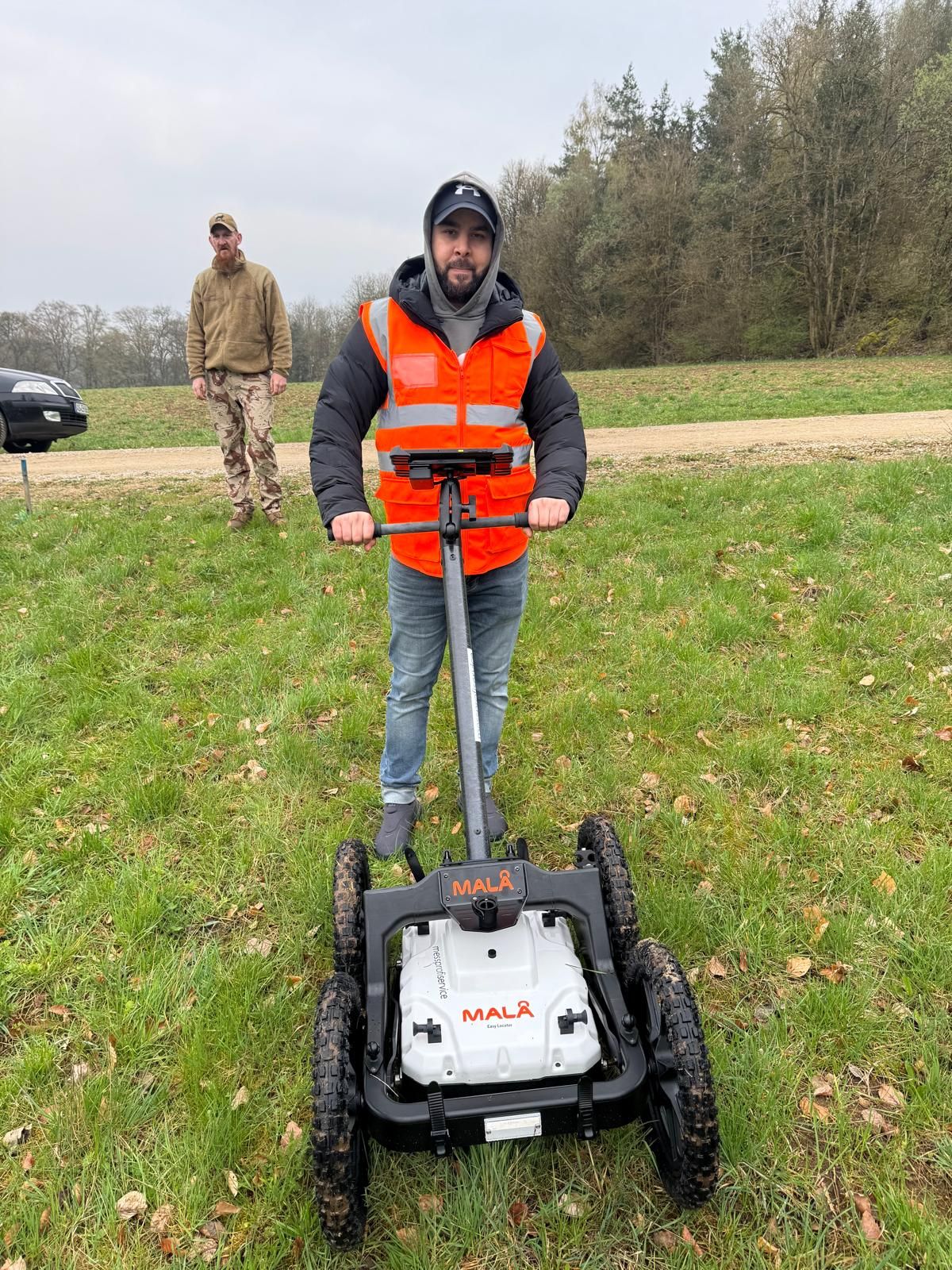


Historical assessment, technical investigation and further work answer different questions. The service overview helps distinguish these tasks in an enquiry.
Compare servicesPreparation connects the commission, site work and handover of findings. Changes to the project can then be incorporated into technical coordination in good time.
Process and documentationAccording to the Westfalen-Lippe explosive ordnance disposal service, only local regulatory authorities are authorised to apply. Contact the responsible office of your municipality with the specific construction project. A private investigation commission has a separately agreed service scope. Clarify the procedure required with the responsible parties before the groundworks concerned.
For specific explosive ordnance procedures, the Lippe district directs enquiries to the responsible office of the relevant municipality, usually the Ordnungsamt. Therefore clarify the local access route using current municipal guidance. A district or administrative district name alone does not determine the contact for your property.
According to the Arnsberg district government, the collection held there is neither supplied to third parties nor available there for inspection. A promise to obtain it would therefore be incorrect. Specialist planning must first clarify which analysis-related result documents are available for the property.
No. It describes the specialist service carried out and the scope of its findings. How the results are to be considered in the local procedure and which further steps are required must be coordinated with the responsible parties. The report does not confer additional sovereign powers on the contractor.
Stop work at the find location. Leave the object untouched and unmoved, move away and keep other people away. From a safe distance, immediately notify the police on 110 and follow official instructions.
The interventions and changes concerned are clearly compared. The responsible parties then clarify which findings still apply to the current status.
Not automatically. Sharing the official image collection and availability of analysis-related result documents are different questions.
Municipal enquiries and responses, plus complete specialist reports with plans, limitations and outstanding tasks. Their relevance to current construction must remain identifiable. Effort also depends on area size and accessibility, proposed intervention depth, suitable methods, interference and usable earlier findings. Preparatory services, interpretation and documentation required are agreed for the specific task with their scope. Cost information concerning official hazard prevention is distinguished from privately commissioned services.
Tell us the municipality, current construction plan and status of the municipal enquiry. Existing information and specialist reports provide a basis for discussing the task FONTANA-EOD should undertake for your project in the Detmold administrative district.
Describe the investigation scope required and information still outstanding. Also tell us which groundworks are due to begin first and which areas are not yet accessible. Necessary preparatory work and handover of results can thus be coordinated in good time.

Whether historical aerial photograph analysis, explosive ordnance surveying, surface surveying using GPR, magnetometry or TDEM, deep-ground surveys, downhole surveys, excavation supervision, area clearance or ordnance recovery is needed depends on the location, ground disturbance, depth, ground and existing documents. An early ordnance assessment provides clarity for tendering, programming, occupational safety and construction.
FONTANA-EOD combines its Section 7 SprengG licence, specialists holding Section 20 SprengG certificates of competence, suitable survey and clearance methods, and traceable documentation. Send the site plan, depth of ground disturbance, construction phase and existing documents for an initial technical assessment.


