Project pathway
The quickest route to the right decision.

Before the next section, project owners, planners and site management need to know which area and depth have been covered and documented. This is compared with the next task and its prerequisites. Send FONTANA-EOD your construction phase plan and existing results. Together we clarify the documents needed for handover.
Assign areas covered clearly.
Show unresolved areas and limitations.
Pass on the valid revision.
A handover during construction documents the status of a specific area covered within the ongoing sequence. It describes the work completed and the area, depth and limits of the technical conclusion. The basis is the defined and documented technical method; merely watching an excavation does not replace the necessary ordnance survey. A partial handover cannot be transferred to untouched neighbouring areas.
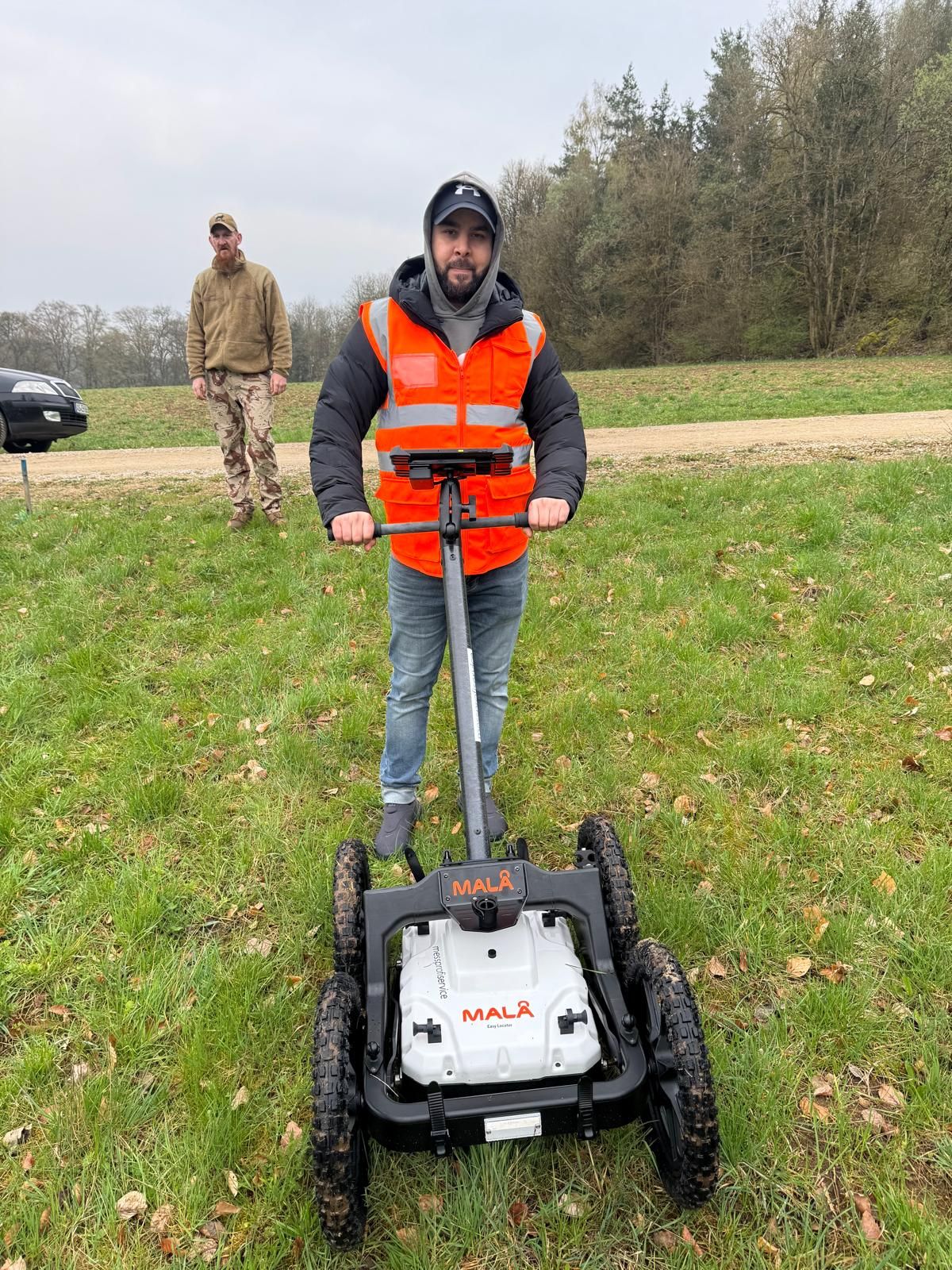
At track 20 in Plattling station, GPR surveying, investigations during construction and subsequent volume clearance were combined. The report explains the sequence and spatial limits of the works.
Working phases and original measurement images from Plattling · Region: Lower Bavaria
Site management and project coordination need an unambiguous match between section, work status and next construction task.
Link the handover to a site plan and an unambiguous section name. The description should be understandable to site management joining later. A verbal reference such as “behind the hall” is not a sufficient permanent location reference.
State whether an area has been investigated, needs further clarification, has been treated or was handed over with a particular limitation. Use terms consistently. Otherwise a coloured plan without a legend can create different expectations for site management and the contractor.
Use the depth conclusion actually documented, including its reference. Compare it with the next ground intervention. An additional deeper shaft, for example, is a new planning question, not automatically covered by the earlier handover.
Untreated edges, obstructions or sub-areas not finally clarified must be visible in the handover. Refer to the associated explanation in the report. The person coordinating the next trade needs this information as well as the overview plan.
Keep date, document reference and underlying plan revision together. A change should identify the earlier revision replaced. This prevents parties continuing with different section boundaries or superseded limitations.
State the subsequent construction task for which documents are checked. If area, depth or method differs, clarify the deviation technically before that intervention. An organisational handover alone does not extend a technical investigation.
The DGUV explicitly distinguishes mere visual observation from ordnance surveying alongside construction. For the next step, the defined method, its actual execution and unresolved areas matter.
The presence of a competent person does not itself mean the ground was technically investigated. Under DGUV guidance, merely observing excavated material is not state of the art. It cannot be treated as equivalent survey evidence.
Read the documented section statusFor ordnance measures alongside construction, documentation must concern the method actually defined and used. The BFR describe technical investigations combined with soil removal. Specific steps and protective measures are defined by specialists for each measure.
Compare the technical conclusion and ground interventionA name such as excavation monitoring does not explain the technical services agreed and performed. Check the specific commission and result documents. The excavation monitoring service page explains the technical distinctions.
Agree the handover pointIf an area is inaccessible or not yet technically investigated sufficiently, the next intervention must be checked against this gap. Historical suspected ordnance, utilities, interfering objects and ground composition affect method selection. The specialist company defines the work needed and its limits. Planners receive an explicitly identified unresolved area and the next clarification step. An adjacent section already investigated is not evidence for that area.
Determine outstanding investigation needsAn unassessed finding or changed excavation area may interrupt the planned sequence. The area affected is assigned to the valid plan and previous results status. Technical specialists establish which assessment or further investigation is needed before the next intervention. Unresolved findings, remaining survey limits and the work status reached are documented together. A suspicious object requires immediate protective action and an immediate emergency call.
Coordinate technical execution and findingsA partial handover must fit the next trade's area, depth and working method. If the intervention exceeds the scope investigated, planners need specific technical clarification. The record shows the status reached, limitations and unresolved areas. Remaining uncertainties and residual risks stay assigned to their scope. The next decision concerns the work step actually prepared; it is not derived from a general plan colour or document title.
Link handover to the remaining construction sequenceThe comparison required depends on the trade using the area next. Naming an area alone is particularly insufficient when depths vary or several construction methods are combined.

Relate handover to the documented alignment and intervention depths. Lateral widening, connection shafts or a route moved later may have a different scope. These additions must be clear in the construction plan and technical coordination.
Identify adjoining areas and ground interventions
Show the normal excavation base, additional deeper points and edges separately. Each task depends on its associated documented conclusion. A uniformly coloured excavation is understandable only if the plan and explanation show the areas and prerequisites actually covered.
Compare investigation scope with the excavationIf installations remain operational or areas are available only temporarily, clear handover points are particularly important. Describe the intended sequence and inaccessible areas. Covering one section does not establish conclusions for areas to be investigated in a later work window.
Prepare handovers within the project processA handover is only as informative as the specialist service underpinning it. FONTANA-EOD aligns the description of work status with the agreed objective and areas actually covered. Site management must be able to see which next task can be considered.

Historical assessments and existing information form part of the project's technical basis. Their spatial assignment remains important when execution is divided into sections. If a previously unconsidered area is added, its knowledge status must be assessed separately.

A conclusion for area-wide excavation does not automatically cover a deep point added later. For piles, boreholes or deep shafts, location, depth and investigation basis must be compared explicitly. The need for additional deep-ground or borehole surveying follows from that specific task.

Describe the approach actually defined and the associated results. A general service name replaces neither the commission nor traceable execution documentation. Handover status must fit the technical work performed and clearly state remaining clarifications.
Design changes, new deeper points and combining section records may change the earlier scope of conclusions. Before the next intervention, affected areas and depths are compared with the documented status.
If a route is moved outside the documented area, the earlier handover cannot support the new alignment. Mark the revised plan and compare it with the investigation before the trade intervenes there. Historical knowledge and existing information are linked to the new intervention plan. Earlier results remain usable only for the evidenced scope. If utilities, ground or survey conditions differ along the new route, additional technical investigation may be needed. Its task and result are assigned to the changed section. The plan should therefore show both the earlier work area and new location, not merely a new axis line.
A new sump or shaft may concern a different depth range. Do not simply apply the surrounding excavation's status. The conclusion relevant to that point and any additional clarification must be established separately. Review needs the point or area on the site plan and the associated section. Elevation reference, final depth and investigation records are compared. If that depth lacks a sufficient basis, further needs are identified and coordinated with the task. Additional technical work has its own documentation; it is not represented retrospectively merely by changing a colour on an old plan.
Collect individual handovers with plans and limitations in a clear index. The final status should still show unresolved areas. The survey report and clearance record provide the technical documents; the ordnance clearance confirmation describes their respective scope of conclusions. Historical information, survey data, survey results and assessment of findings are not interchangeable documents. They show different work steps. The survey report and any clearance record must identify the work and results belonging together. The conclusion derived is related to the section concerned. If identifiers or revisions differ, assignments are clarified before use by another trade. Provenance, investigation and the next decision thus remain traceably linked.
Handover is prepared before the next trade intervenes. The steps connect technical documentation and construction coordination without implying general clearance for the entire project.
Describe the next work intended in the area. Record location, depth and method. Handover status is thus related to specific execution rather than treated as a general area status. Initial documents also include the historical basis for suspected ordnance and aerial photograph analyses. Their boundaries are compared with the next phase. Missing knowledge for a newly added area is clarified before method selection based on it.
Compile specialist result documents and associated plans. Check sections actually covered and unresolved areas. Documents from other phases retain their original reference. Survey data, assessments, survey reports and clearance records are assigned to their commissions where available. The documented investigation scope and conclusion derived remain separately identifiable. Older documentation may be important but does not automatically answer every new-phase question.
Compare planned work with the records' spatial, depth-related and technical scope. Clarify any deviation before the intervention, even if only a small area changes. If further investigation is needed, suitable technical work and operating conditions are prepared and performed within the commission. Utilities, ground, access and survey limits are considered. A preferred operational date does not replace method selection. Changed conditions are clarified with the technical specialists before the step affected.
Identify the area, underlying documents and current plan revision. Keep limitations and outstanding points with the technical conclusion. A clearly named handover document supports coordination. Specialist assessment links measurements and work results to agreed objectives. Anomalies still requiring work remain identified as open findings. The report and results plan should agree on the scope reached and conditions for use. Actual clearance work requires the corresponding clearance records in the handover.
Ensure site management and the trade concerned receive the applicable documents. Clarify who answers questions and communicates changes. Filing documents alone does not prove the status needed for the next work has been understood.
Compare revised planning with the earlier handover. Record the new status clearly and inform affected parties. Earlier records are retained for provenance but must not continue unnoticed as the current execution basis.
Several partial handovers must remain understandable as a coherent set later. A final index should reflect actual status and must not conceal unresolved areas through an oversimplified overview.
Assign reports, plans and appendices to the same section name. Documentation should show the task covered and basis of results. A summary can improve orientation but does not replace the full technical context. For Phase C clearance measures, the BFR documentation specification lists, among other things, the clearance site setup plan, daily site report and updated clearance map. These have different functions: work progress and spatial results must be comparable. The documents and formats applicable to your project are defined from the requirements and agreed scope.
Record which revision applies to each area. If a document is supplemented or replaced, its relationship to the earlier version must remain traceable. Handover can then be understood on the same basis even when project participants change. Unique borehole or investigation-field identifiers can link plans and records. If trades use different plan names, reconcile them before handover; otherwise the same location may be understood differently even though each document is legible.
Include unresolved or untreated sub-areas in the combined status and identify their relevance to further planning. A final report documents the agreed work completed; its title alone does not extend that scope. Record effects on the next task: which area remains excluded, what investigation is still needed and who arranges clarification? The parties can then distinguish the section actually prepared from the unresolved part. This matters especially if the next trade needs only a narrow corridor within a larger site.
Documentation links work performed to a spatially and technically limited conclusion. For the next task, investigation, result and remaining limits must be read together. Individual statements must not be taken out of context.
Likewise, merely observing excavated material does not replace a necessary technical ordnance survey. The defined method and its documented execution are decisive.
Compare documented depth with execution planning, including the elevation reference. A depth from an earlier ground surface may become misleading after terrain changes. Slopes, working areas or local deeper points may also differ from a simplified excavation outline. What matters is whether the actual intended work falls within the existing technical conclusion. The conclusion needed for the next excavation layer must be relatable to the current working level. For a planned clearance method alongside construction, technical execution describes the survey before each soil removal and when the responsible person permits the next step. The BFR KMR A-9.4.3 explicitly distinguish this sequence of investigation followed by removal in layers from mere visual observation.
Obstructions, inaccessible areas or method-related limits must remain visible for later planning. When plans are combined, they must not inadvertently receive a neighbouring treated section's colour or name. Further work is defined by specialists and linked to the task. A general completion note does not remove the limits. Identify each gap's reason, such as an inaccessible edge, utilities or an uninterpretable area. Different causes may require different next steps. Removing an obstruction later does not itself resolve the investigation question; the newly accessible area is assessed for the intended intervention.
The plan shows location while the report explains conclusions and prerequisites. Sharing only extracts may lose essential limitations. Keep related documents available with revisions and appendix references. Later site management should be able to trace results to areas and identify questions needing clarification before the next work.
A technical conclusion is useful through its relationship to planned work. Read the full status and distinguish applicable documents from unresolved deviations.
Assign applicable documents to the intended work and pass them on with prerequisites. The technical meaning of the status must remain clear to the next trade.
Read the section handover scopeMark the changed area or depth and clarify additional needs. Proximity to an area already covered does not justify transferring the existing conclusion.
Check the differing ground interventionObtain the associated explanation and assign the question to the working area affected. Until the technical comparison is made, a simplified colour must not replace the necessary conclusion.
Consider result documents togetherCompile its planning and available knowledge. Identify differences from the earlier task. FONTANA-EOD can then focus coordination on the next specific intervention.
Coordinate the next construction sectionFONTANA-EOD links the agreed specialist service to a traceable presentation of the area covered. Documents should enable the client and site management to assign results and remaining questions to the next task. Clear names, spatial references and an understandable revision are part of this.
Documentation identifies the commission actually performed. Its name alone does not imply extra areas, deeper coverage or additional objectives.
Section names match in plan and report. Assignment remains possible even if local personnel or visible site conditions change.
Technical limits are passed on with the result. They disappear neither from an overview nor from handover to the next trade.
New planning is compared with the previous basis. Current status is clearly named while older records' provenance remains traceable.
Parties know who explains the conclusions and who is responsible for design changes. Different responsibilities are coordinated in the project.
Documents are used for a specific task. An organisational handover alone extends neither technical investigation nor an official decision.
Technical conclusions, planning and execution coordination have different functions. Handover should connect these contributions without confusing responsibilities through a signature or general status label.
The client and appointed planners describe intended use and subsequent interventions. Changes in location, depth or execution enter technical coordination. Existing requirements and documents are considered with their respective scope.
Technical specialists assign the method used and documented results to the agreed task. Outstanding points and limits form part of the conclusion. Authorisation, competence and responsibility requirements follow from the activity actually performed.
Site management coordinates document use for the next task. The next trade needs the valid status with visible limits. Queries or deviations are clarified with the responsible specialists before the intervention.
Documentation describes a specific measure. Execution, safety and authority interfaces depend on activity, location and project. The company documents its commissioned measure; official decisions belong to the competent authorities.
The Explosives Act and 1. SprengV provide a framework for relevant authorisation, competence and responsibility questions. Assignment must fit the activity actually intended. A documentation commission is therefore distinct from responsible execution of technical investigation or clearance.
Risk assessment and protection are linked to the defined method. DGUV Information 201-027 addresses clearance; for methods alongside construction, the BFR KMR refer to found-ammunition provisions in Appendix 5 of DGUV Rule 113-003. Technical specialists define the execution and briefing required for the specific measure.
Official and contractual requirements are considered with their actual project relationship. The BFR KMR distinguish technical clearance methods and Phase C documentation. A daily report describes work progress; the technical conclusion evidenced for a subsequent intervention follows only from the associated investigation and results context.
The BFR KMR have a defined scope for federal properties. For other projects, the applicable requirements and contractual provisions must be assessed.
Stop work immediately. Do not touch or move the suspicious object; leave the immediate area and keep others away without putting yourself at risk. Notify the police on 110. The competent authorities and responsible persons determine further specialist work and applicable reporting routes.
Documentation does not standardise regional responsibilities or operational requirements. State the location and project setting so that coordination reaches the parties actually concerned.

Assign documents to the actual location and include official information in full. A region alone describes neither scope nor procedure. At several locations, results and prerequisites must remain separately traceable.
Prepare location-specific coordinationFor transport routes, utilities or operational sites, operational permissions and technical ordnance records may both be required. These different statements must not be confused. Describe which trade will work where and under which operational conditions.
Assign project setting and handoversClear terminology helps handover. What matters remains the full document's conclusion with its spatial, depth-related and technical scope.
It describes the work actually performed and documented in an area. Its meaning follows from the task and result documents.
It concerns a delimited part of the project. Further areas or later interventions are included only where the documents specifically state this.
It identifies a limit of the existing conclusion or work. Subsequent planning must respect it and clarify any further step separately.
It combines results for the agreed scope. Outstanding points remain visible; a final compilation does not extend the investigation.
Visible site conditions alone do not show the full technical work status. For the next intervention, the service, results and outstanding questions are assessed together.
The approach actually defined and used matters for assessment. Specification and results must be read together. A general label or a person's presence does not provide a complete investigation record.
Identify technical work and supportPlans, reports and appendices should identify the same area covered. Assignment remains necessary when partial handovers are later combined. Changes and limits must be traceable in the current revision.
Assign section records
Compare the intended intervention with existing documents. Identify deviations and questions for specialist coordination. The next step thus relates to the documented work status.
Coordinate the next intervention technically
The investigation objective, existing results and planned follow-up work must be technically consistent. Use the professional terminology for ordnance assessment consistently and read results with their specific limits.
The conclusions required depend on the construction task. The service overview helps distinguish investigation and work tasks and assign documents to the scope actually agreed.
Compare service and objectiveDocumentation belongs in the overall process. Earlier knowledge, current work and next task must be linked clearly so handovers remain technically usable.
Bring process and records togetherShared terms help coordination between site management, specialist company and trade. A label does not replace the specific conclusion with its area and depth assignment.
Read section documentation termsNo. Its scope follows from the area identified and documented limits. Other parts of the property are not automatically investigated or cleared. Subsequent construction planning must be compared with the section actually covered.
A signature does not automatically make a daily report clearance for a particular ground intervention. Its content, task and assignment of documented results are decisive. Check whether the required technical conclusion, including area, depth and limitations, is actually included.
The DGUV does not regard merely observing excavated material as a state-of-the-art method. The technical investigation and protective measures required must be defined by specialists for the specific measure before the ground intervention concerned.
The changed ground intervention is compared with the documented work status. If it affects different areas, depths or technical prerequisites, the next steps must be clarified before that intervention. Changes should reach the parties with a clearly identified design revision.
Define recipients for the specific project. In particular, coordination should consider the client, technically responsible parties, site management and the next trade. It must be clear who receives the documents and who decides their significance for the next task.
A marking's meaning follows from the legend, associated report and documented scope. Colour alone explains neither investigation depth nor technical limitations. The next ground intervention must therefore be compared with the complete, related documents.
Assign each partial handover to the relevant area and valid document revision. Keep associated plans and limitations together. Unresolved areas must remain visible in the combined status; compilation does not extend the scope technically covered.
Hand over the current plans and results with associated reports, appendices and outstanding points. Explain which documents apply to the next construction task and who answers technical queries. Earlier superseded versions should remain distinguishable from the current basis.
Preparation depends on the section needed next and documents already available. Describe the task and outstanding questions.
Send the current phase or execution plan with area, depth and planned work. Mark changes from earlier coordination. Review can then focus on the affected transition between trades. State location, section or land parcel and any route or borehole points. Utility and existing-structure plans, obstructions, access and available windows help preparation. Identify the decision needed for the next intervention and when the trade is to start.
Provide the relevant reports, plans and handover documents in full. Retain appendices and limitations. Identify documents currently applicable and those explaining only the history.
State who explains the design, who is responsible for investigation status and who coordinates the next trade. Targeted queries can then reach the right person.
Whether historical aerial photograph analysis, explosive ordnance surveying, surface surveying using GPR, magnetometry or TDEM, deep-ground surveys, downhole surveys, excavation supervision, area clearance or ordnance recovery is needed depends on the location, ground disturbance, depth, ground and existing documents. An early ordnance assessment provides clarity for tendering, programming, occupational safety and construction.
FONTANA-EOD combines its Section 7 SprengG licence, specialists holding Section 20 SprengG certificates of competence, suitable survey and clearance methods, and traceable documentation. Send the site plan, depth of ground disturbance, construction phase and existing documents for an initial technical assessment.


