Project pathway
The quickest route to the right decision.
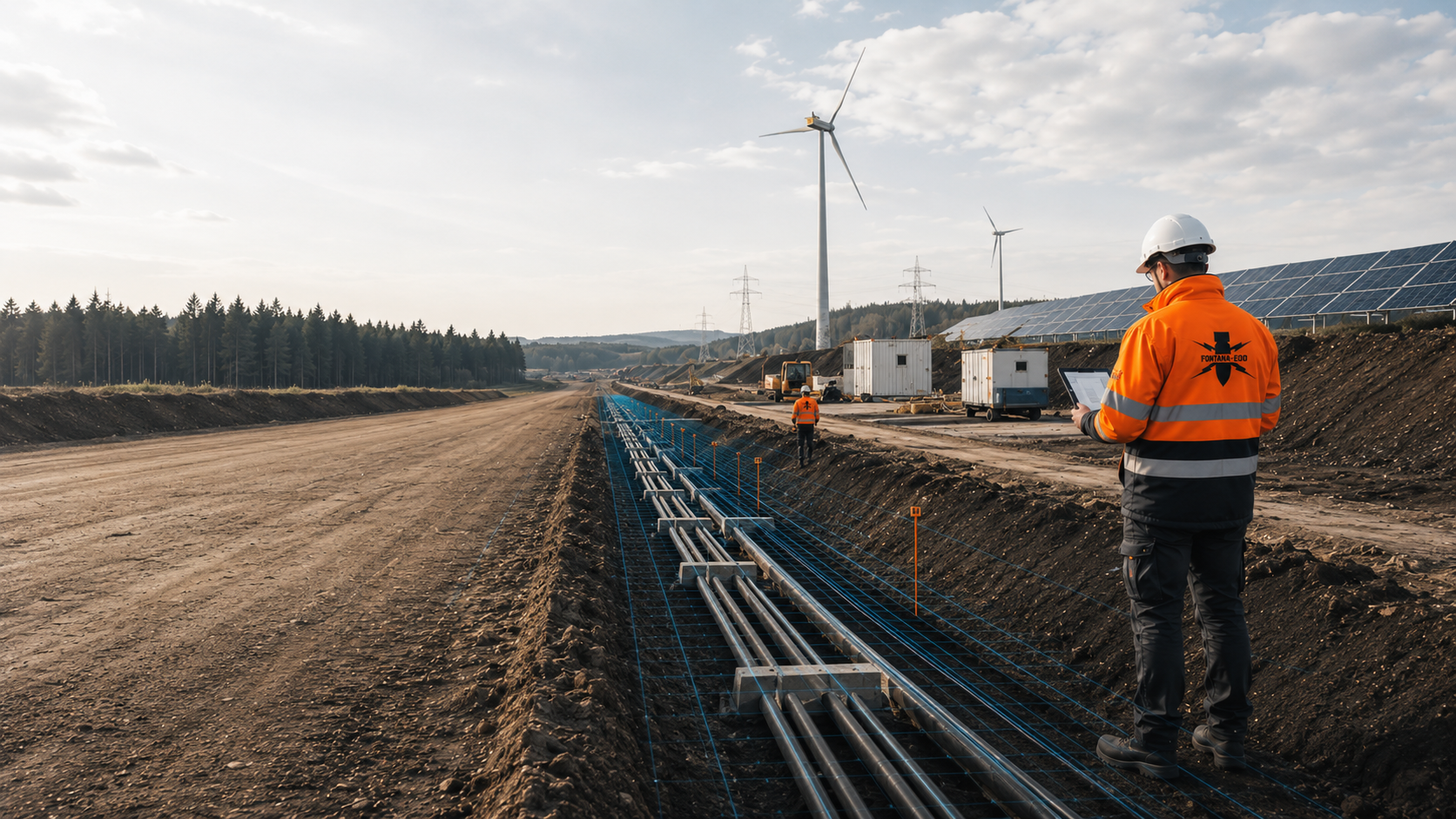
For underground cable construction, standard trenches, joint bay structures, crossings and grid installations must be assessed separately for indications of explosive ordnance. FONTANA-EOD plans suitable investigations according to chainage, working width, depth and construction method. Send route plans, cross-sections, special structures and construction phases so that services and documentation can be defined before cable excavation, drilling and foundation works.
Assign sections and special structures.
Investigate trenches, joint bays and drilling paths.
Document route volumes addressed.
Before cable excavation and drilling, existing indications of a suspected hazard and planned ground interventions are used to clarify which explosive ordnance investigation is needed. Standard trenches, joint bay structures, crossings, grid installations and ancillary construction areas are considered. The required scope depends on the actual route geometry with working width, base depth, retaining structures, excavations and planned special crossings.
The standard trench, joint bay structure, crossing, grid station and ancillary construction area have different depths, working widths and construction conditions. Explosive ordnance assessment is aligned with these geometries.
Section and lot boundaries are maintained so that designers, civil engineering teams, cable pulling teams and subsequent network documentation use the same spatial work status.
Construction geometry changes particularly at crossings, watercourses, transport infrastructure, joint bay locations and network nodes. Depths, excavations, working widths and construction times there differ considerably from the standard section. These special locations are separated from the linear route early and planned individually.

The standard trench is described by its axis, working strip, trench depth, slope or retaining structures and lateral storage and vehicle areas.
Multi-circuit cable installations, duct bundles and thermal bedding can create different construction cross-sections within the same route.
The documentation follows the actual construction axis rather than only the early spatial planning corridor.
Investigate the standard trench and working strip
Joint bay locations, cable pulling pits and pulling areas need larger excavations, assembly areas and logistics working spaces than the standard trench.
Coordinates, dimensions, base depth, retaining structures and subsequent cable entries are recorded as a separate construction site.
A linear route investigation covers these deeper structures only where their full volume of ground affected is included.
Investigate joint bays and cable pulling structuresRoads, railway lines, watercourses, conservation areas and existing utilities are often crossed beneath using trenchless methods.
The launch pit, reception pit, pilot bore, reaming, drilling path and possible positional deviations together form the relevant investigation geometry.
A near-surface investigation along the axis does not replace a depth-related assessment of the drilling volume.
Assess the drilling path and pitsNetwork nodes, compensation installations, switchgear buildings or converter areas create foundations, cable basements, earthing networks, drainage and extensive excavations.
These plant areas are planned and documented independently of the linear route status.
Ownership, operator and procurement boundaries are clearly identified at handover.
Coordinate grid installations and the routeTemporary access routes, soil depots, cable drum areas, cable pulling areas and site facilities may lie outside the permanent protection strip.
Soil removal, surfacing, drainage and heavy logistics determine the actual intervention.
The project investigation considers these areas where they involve work relevant to explosive ordnance assessment.
Record logistics and ancillary areas
Groundwater, open dewatering systems, drains, pump sumps and discharge pipes can require additional trenches and excavations.
The location of these temporary systems is checked against the civil engineering design and the actual construction conditions.
Dewatering measures added later are not automatically covered by the documentation for the cable route.
Clarify the survey requirements for dewateringPower cable routes pass through route option planning, approval, detailed design and a construction phase carried out in sections. The explosive ordnance assessment is updated as reliable route and structure designs become available.
Explosive ordnance planning is coordinated with approval conditions, land access, ground investigation and dewatering plans, and traffic management. This makes clear which prerequisites must be met before a contract section is released and which work is only possible at a later construction stage.
Historical indications, known finds and available information from the authorities are first related to the possible route corridors.
Route options can be compared in terms of suspected hazards, accessibility, special crossings and additional assessment work.
The early corridor assessment identifies further survey requirements. It does not replace any necessary technical survey of the construction alignment selected later.
Assess route options using historical evidenceThe route alignment, working strip, depth profile, joint bays, special crossings, grid stations and ancillary construction areas are translated into specific assessment areas.
Design revisions and chainage references must be consistent between approval, tendering and construction.
Changes in alignment or additional structures are checked against the current status of the work.
Assess the detailed route designBoreholes, cone penetration tests, groundwater monitoring points and soil sampling often involve ground intervention before construction of the cable route itself.
The point location, target depth, drilling method and equipment position are assessed for explosive ordnance hazards.
Clearance of individual ground investigation points does not provide an assessment of the later cable trench.
Assess ground investigation points and monitoring locationsChainage, quantities, civil engineering cross-sections, crossings, enabling work, interference zones, data formats and documentation are described consistently across contract sections.
Provisional items are given defined triggers and clear acceptance criteria.
Interfaces between route contract sections and grid installations are clarified early.
Structure route tendering and documentationCivil engineering work, shoring, dewatering, ducts, cable pulling and reinstatement progress along the route in sections.
The site management team needs an up-to-date status of chainage locations already addressed, subject to limitations or still outstanding.
Suitable supplementary methods are assessed for outstanding areas. Explosive ordnance surveying during construction is only an option if it is technically suitable for the planned excavation.
Coordinate the sequence of sections and hold pointsAlternative alignments, changed crossings, additional joint bays or modified stations may lie outside the original survey.
Before construction, we check which existing data remain valid and where additional work is required.
The previous report is retained as a separate design revision and is not overwritten.
Check design changes against the route statusLong cable routes are not assessed as a uniform area. Suspected hazards, ground conditions, interference from existing structures, construction methods and depth can change over short sections.
One route section may show no historical indications but be subject to strong technical interference; another may offer good survey conditions but have specific indications of explosive ordnance. Historical assessment and technical survey feasibility are therefore documented separately before being brought together for the construction decision.
Aerial photographs, archives or regional records indicate possible explosive ordnance contamination along part of the route.
The indications are related to chainage, the working strip, joint bays and crossings.
The technical assessments required for the final construction alignment are then defined.
Relate suspected hazards to route sectionsAgricultural or undeveloped sections may permit systematic near-surface surveying.
Ground conditions, moisture, vegetation, the target object, working width and excavation depth determine the grid and method.
Not every area within the planning corridor automatically forms part of the later construction trench.
Define the survey method for the standard corridorExisting utilities, rails, reinforcement, foundations, previous excavations and transport infrastructure can strongly obscure survey data.
Known installations are mapped. Supplementary methods and suitable survey access are assessed for areas where the data cannot be evaluated adequately.
The limitation remains visible in the project records.
Select suitable surveys for sections affected by interferenceHDD bore paths, deep launch and reception pits, joint bays or cable basements extend beyond the standard trench.
The assessment geometry follows the entire volume of ground affected by the point intervention, linear works or excavation.
Results for the standard section apply only within the documented location and depth; deeper special structures are assessed separately.
Survey deep special structuresTraffic, existing structures, water, vegetation or a lack of site preparation may prevent surveys in advance.
The section is identified on the plan as not yet adequately surveyed. Suitable supplementary methods and possible access after site preparation or dismantling are defined. Necessary surveys and protective measures are planned before ground intervention associated with vegetation clearance, breaking out surfaces, demolition or creating access.
The site management team receives a clear hold point before ground intervention.
Coordinate methods for areas that become accessible laterSurvey anomalies are assessed for plausibility against utility plans, the route alignment and known sources of interference.
Survey anomalies undergo technical follow-up investigation or exposure with clear chainage and construction section identifiers. Recovery of confirmed explosive ordnance is coordinated with the permitted scope of work and the local responsibilities. If an unexpected suspicious object is encountered, work is stopped immediately and the responsible authorities are notified without delay.
Findings, handover and outstanding areas remain documented by chainage.
Clarify investigation of findings by chainageThe documentation must link the linear corridor, individual structures and deep crossings using the same location and plan references. Assessments remain limited to the section actually addressed.
In addition to the technical results, handover points between design revisions, contract sections and construction companies are recorded. This allows the overall project management team to identify which sections have been fully addressed, assessed subject to limitations or remain inaccessible.
Before cable pulling, the site management team checks the planned section against the documented status of civil engineering work and surveys.
The alignment, kilometre or chainage references, working strip, contract sections and construction sections are clearly recorded.
Design changes are assigned a date and revision identifier.
Route options or ancillary areas not considered remain identifiable.
Aerial photographs, maps, previous uses, find information and information from the authorities are documented with their sources and scope.
Data gaps are identified by section.
The historical assessment follows the current construction alignment.
Survey areas, route sections, ground investigation points, joint bays and crossings are given unique identifiers.
Coordinates, depths and work status remain linked throughout planning and fieldwork.
Additional points are recorded in separate updates.
Ground conditions, surfaces, water, utilities, traffic, reinforcement, scrap metal and accessibility are described by section.
Technical limitations are shown spatially.
A specific follow-up measure is identified for each data gap.
Anomalies, technical installations, exposures and actual finds are assessed separately.
Each outstanding point is assigned a status, responsibility and time reference.
Completed measures remain traceable by chainage and type of work.
Maps, lists, records and conclusions are initially prepared for individual sections or contract sections.
An overall status overview links the individual packages without obscuring their boundaries.
Later route changes are recorded as updates.
The current construction sections are checked against the route plan and survey results in the project records. Each dataset is assigned a clear chainage, structure and plan reference.
The coordinate system, chainage conventions, file naming and asset register are agreed early for the subsequent grid documentation. These arrangements allow partial reports to be combined and chainage locations to be matched unambiguously across contract boundaries.
During later maintenance or cable repairs, the original status of the work can be checked again. This requires the repair location, new excavation and planned depth to be checked against the documented sections and special structures.
The spatial planning corridor, approved alignment, tender design and construction drawings are maintained under revision control.
This keeps the basis of each survey traceable.
Construction contracts, construction sections, standard trenches, special structures and grid installations are assigned a consistent hierarchy.
Handovers between contractors retain the same location references.
Boreholes, joint bays, launch and reception pits, chambers and stations are recorded with coordinates, depth and status.
Deep special structures remain distinguishable from the standard trench.
Anomalies, known utilities, interference zones and technical data gaps are assessed separately.
Each entry is assigned a follow-up decision and a section.
Working conditions, lengths actually addressed, excavation layers and interruptions are documented continuously. After actual exposure or clearance work, the corresponding findings and clearance records are included.
The records support site management and quantity reconciliation.
Maps, lists, records and outstanding measures are handed over in an agreed data structure.
Later additions remain traceable separately from the original status.
The work follows the developing design and the actual construction sequence. Results must be available before the planned ground interventions begin in each section.
Special structures are prioritised according to their design readiness. A crossing defined early can be assessed separately while a standard section still subject to change initially remains subject to historical assessment only. The project records explicitly show these different stages of readiness.
Construction sections with high programme risks or complex crossings can be prepared as a priority, while corridors not yet defined explicitly retain their planning status.
The route design, length, contract sections, construction methods, grid installations and required decision are described.
Aerial photographs, maps, historical records and regional information are related to the corridors.
Standard trenches, joint bays, crossings, ground investigation points, grid installations and ancillary areas are recorded separately.
Ground conditions, interference, depth, accessibility, water and construction schedules determine the technical approach.
Chainage, site preparation, working strips, HSE, traffic management and data handover are coordinated.
Lines, points and excavation sections are addressed according to the agreed geometry and construction phase.
Readings, limitations and exposures are assessed for plausibility against the route plan and known installations.
Reports, maps and outstanding measures are updated for planning, civil engineering work and cable pulling.
Underground cable projects combine a recurring standard cross-section with numerous changes in depth, excavations and special structures. A reliable explosive ordnance assessment must represent this geometry in three dimensions and by chainage.
The volume of ground affected does not necessarily end at the trench edge. Shoring, topsoil stripping, storage, haul roads, dewatering and equipment movements may affect areas to either side. The assessment area is therefore derived from the actual construction work, rather than the cable cross-section alone.
For the open cable trench, the alignment, working strip, trench width, excavation depth, slopes or shoring, cable or duct position and lateral working spaces are described. The technical assessment relates to the actual ground intervention, rather than a planning corridor of an assumed uniform width.
Joint bay structures, cable pulling pits, launch and reception pits and grid installations are recorded as separate geometries with their plan dimensions, depth and construction stage. For HDD or thrust boring, the bore path, reaming and foreseeable deviations form part of the relevant volume at depth.
Design changes are updated by chainage. If the alignment moves, an additional joint bay is needed or the crossing method changes, the new geometry is checked against the existing documentation. Earlier results and later additions remain identifiable with their respective design revisions.
Alignment, chainage, width, depth, slopes or shoring determine the linear assessment area.
Vehicle movement, storage and excavation areas are included only where relevant ground interventions take place.
The excavation, assembly area, shoring, excavation depth and cable approach form a separate geometry.
The greater construction depth is not inferred from the standard trench.
The launch pit, reception pit, bore path, reaming and positional deviations are considered together.
Surface surveys and the deep bore route remain technically distinct.
Coordinates, target depth, drilling method and equipment position are defined for each ground investigation point.
Additional points require a new status check.
The substation, transfer station, switchgear building and cable basement are documented as a separate installation construction area.
Foundations and earthing systems may have different depths and interference conditions.
Design revision, chainage, length addressed, outstanding special structures and handover status are maintained continuously.
Only documented volumes of ground are handed over to the next construction process.
Long power cable routes pass through different historical, geological and technical settings. Agricultural land, transport corridors, commercial areas, watercourse crossings and grid nodes may present entirely different survey conditions and responsibilities within one contract section.
Select surveys according to route conditionsWhere routes run alongside existing utilities or within narrow infrastructure corridors, it is also necessary to clarify which technical installations are known and which areas need a separate assessment despite their proximity to existing infrastructure. An existing utility neither provides sufficient evidence for the new volume of ground affected nor automatically represents only a source of survey interference.
Determine suitable assessments for separate volumes of groundThe methods address different physical and spatial questions. The standard trench, deep crossing, joint bay structure and inaccessible section therefore do not necessarily require the same service.
Defines suspected hazard areas and data gaps along possible or selected routes.
It does not demonstrate the presence of objects currently in the ground.
The result supports route option selection and technical prioritisation.
Detects ferromagnetic anomalies in suitable, accessible corridors.
Utilities, rails, fences and scrap metal can affect data evaluation.
The grid and survey objective are selected for each section.
TDEM measures time-dependent electromagnetic responses and can provide additional information on conductive anomalies in suitable underground cable sections.
Depth, ground conditions and technical infrastructure affect the assessment.
A deep crossing remains a separate geometry.
Can show changes in underground structures and materials where ground and surface conditions are suitable.
Reflections do not allow automatic object identification.
Moisture and heterogeneous made ground can limit the depth of usable data.
Assesses ground investigation points, deep excavations and defined crossing or installation locations.
Coordinates, target depth and the subsequent construction method must be consistent.
It does not provide a general assessment of the route beyond the point geometry.
Where explosive ordnance detection during construction is technically suitable, each working layer is surveyed and evaluated using technical methods. Controlled removal in layers and supplementary visual inspection then follow; these steps are repeated down to the agreed excavation base.
Excavation layers, shoring conditions, equipment operation, hold points, authority to issue instructions, communication channels and documentation are defined in the work instructions before work begins. Simply observing the excavator is insufficient.
The assessment applies only to the section supervised.
Designers, the field team and site management use the same chainage and point identifiers. Before construction, the route design, survey results and outstanding tasks are checked against each other.
For long projects, traceable interfaces are as important as the individual survey. Chainage, point identifiers, contract boundaries and handover formats are defined so that results from different survey campaigns and contractors can be combined without losing meaning.
FONTANA-EOD starts with the specific construction task: standard trench, joint bay, crossing, borehole location, grid installation or a later excavation stage. Each volume of ground is assigned its own technical question and documented within the same chainage system.
Methods are selected according to the suspected hazards, target object, depth, ground conditions, water, technical interference and accessibility. Areas that cannot be evaluated adequately are identified on the plan. Suitable supplementary methods and access options are assessed for these areas.
Fieldwork is coordinated with setting out, civil engineering design, traffic management, dewatering, HSE and the construction programme. Sites progressing along a route and multiple contract sections require clear handover and data rules.
Reports identify the volume of ground along the route actually addressed and its limits. Before construction, a changed alignment, greater depth or additional special structure is checked against this status.
For routes with numerous special structures, status and priority are recorded separately. This allows work to continue in a cleared standard section while a deep crossing or changed joint bay location remains subject to technical clarification.
The alignment, construction section, depth and design revision form the common spatial basis.
The standard trench, joint bay, crossing and grid installation are assessed individually.
Methods and supplementary measures follow the ground conditions, interference, target object and construction stage.
Contractors and construction phases use the same identifiers and handover rules.
Areas that cannot be surveyed or accessed remain visible on the site plan.
The documentation states the status, boundary and next measure for each section.
For projects spanning several regions, planning areas, local authority procedures, construction companies and data standards are assigned to each contract section. Shared chainage and point identifiers show which areas have been surveyed and where tasks remain outstanding. Partial reports are combined with their spatial limits retained.
The documentation must be linked to the route alignment, kilometre or chainage references, construction section, depth, construction method and design revision. FONTANA-EOD uses these details to describe the areas requiring survey and the documentation needed by grid operators, designers and site management.
Grid operators, designers and construction companies define who provides documents, reports design changes and receives results. The responsible public authorities carry out their respective hazard prevention duties.
Define the grid requirements, project phase, route design, programme, procurement and documentation requirements.
They coordinate the overall project and its interfaces.
Translate the corridor and approval into the alignment, construction cross-section, joint bays, crossings, borehole locations and grid installations.
Design changes are handed over with chainage and revision references.
Coordinate access, rights of use, land management, site preparation and temporary areas.
The legal right to access land does not replace an explosive ordnance assessment.
Implement working strips, excavations, crossings, hold points and section handovers.
Changes to alignments, depths or additional structures are reported before construction.
Assesses suspected hazards and the geometry of the ground affected, carries out the commissioned assessment and documents results and limitations.
The service remains limited to the commission and the section actually addressed.
In Germany, the ordnance disposal services of the federal states and the locally competent authorities carry out hazard-response and find-management duties. Their involvement is established for the project location; outside Germany, local responsibilities apply.
The local public order authority and, where applicable, building control are involved according to their project responsibilities. Conditions and contacts are assigned to the actual route sections and special structures; reporting procedures are defined before work begins.
Long construction corridors, deep special structures, traffic crossings, dewatering and changing contractors require a clear structure for hazards and responsibilities.
Reporting procedures and responsibilities may change where sections cross state or district boundaries. The project organisation therefore records which local authorities must be involved in an incident for each contract section and special structure.
In Germany, § 7 SprengG concerns the commercial authorisation for activities requiring authorisation; § 20 SprengG concerns the certificate of competence of responsible persons. Under § 1b SprengG, searching for found munitions also counts as handling them. The requirements applicable to the project depend on the activity actually commissioned and the allocation of responsibilities.
The risk assessment brings together survey methods, excavation, shoring, dewatering, drilling techniques, construction traffic, electrical installations, exclusion zones, escape routes and communication. Differences between contract sections and construction stages are taken into account.
DGUV Information 201-027 supports risk assessment and protective measures for explosive ordnance clearance work. The Baufachliche Richtlinien Kampfmittelräumung contain requirements for historical and technical investigation, clearance concepts, procurement and documentation within their defined federal remit. Their application to the specific underground cable project is clarified separately.
If an unexpected suspicious object is encountered, stop work in the affected section immediately. Do not touch, move or continue to expose the object. Leave the danger area and keep others away without putting yourself at risk. In Germany, notify the police immediately on 110; outside Germany, use the local emergency reporting procedure. The responsible authorities determine the next steps. Then inform site management and those responsible for occupational safety.
The division of responsibilities also covers setting out, site preparation, traffic management and dewatering. These enabling works affect accessibility and survey feasibility, but are not implicitly assumed to form part of the explosive ordnance fieldwork.
The First Ordinance to the Explosives Act (1. SprengV) includes requirements concerning specialist competence and state-recognised training courses. For underground cable routes, the required qualification is matched to the survey or clearance work actually commissioned.
DGUV Rule 113-003 concerns the dismantling or destruction of explosives or corresponding objects and also includes the disposal of found munitions. It applies according to this field of activity; it does not replace a risk assessment specific to the planned ground intervention.
The company, responsible individuals and specific activity must be compatible in terms of technical competence and explosives law.
Civil engineering work, shoring, dewatering, drilling, traffic, exclusion zones and escape routes are assessed by section.
Chainage, quantities, methods, data formats and acceptance criteria are defined consistently across contract sections.
Site management, HSE, the project promoter and responsible authorities follow a procedure agreed in advance.
The route design, special structures, quantities, qualifications, enabling works and documentation are clearly described.
Interfaces between contract sections are assigned clear handover criteria.
Site preparation, setting out, working strips, utilities, equipment, briefings and hold points are checked against the current plan.
Changes are incorporated before work begins.
Stop work immediately, do not touch, move or uncover the object further, leave the immediate area and keep others away without putting yourself at risk. In Germany, notify the police immediately on 110. Outside Germany, use the local emergency reporting procedure.
The next steps for the relevant chainage location are coordinated with the responsible local authorities.
Plans, point lists and records use the same chainage to show which sections have been surveyed and which tasks remain outstanding.
The documents support both the final report and ongoing coordination of civil engineering, HDD, joint bay construction and cable pulling. Each discipline can identify the status relevant to its work using the same spatial references.
Records referenced by chainage also facilitate coordination with setting out, construction supervision and cable installation. Outstanding special structures remain identifiable even where neighbouring standard sections have already been handed over to the next contractor.
The underground cable overview links chainage, standard trenches, joint bays, crossings, grid installations and ancillary areas to the current status of work.
Assess underground cable sections within the energy project
The route mapping defines chainage locations with substantiated indications, data gaps and prioritised technical assessment areas along the underground cable alignment.
Review historical indications along the route
Documentation for joint bays, boreholes and grid installations remains limited to the documented point, linear and depth geometry of each structure.
Survey joint bays and special structures at the relevant depths
The suitability of construction-phase ordnance surveying is assessed for each excavation layer. The documented investigation area limits the statement’s scope.
Supervise trench and pit excavation
The underground cable records distinguish survey anomalies, existing utilities, technical sources of interference, confirmed finds and outstanding follow-up measures at each chainage location.
Record findings and outstanding measures by chainage
Baseline data, fieldwork, construction conditions, method limitations and the next decision are brought together by construction and contract section.
Link contract section reports and project records

Historical hazard assessment, depth-specific surveys, excavation supervision, investigation of findings and documentation are assigned to the relevant route or installation section.

Plan ordnance assessments for transport, utility, energy and other infrastructure projects according to their ground interventions.
Have the project surroundings assessed by specialists
Distinguish utility corridors, crossings, foundations and installation areas by construction method and intervention depth.
Assess utility and energy project requirements
Evaluate historical indications and data gaps along the underground cable route.
Clarify historical suspicion indicators
Relate boreholes, foundations, chambers and deep points on power cable routes and underground cable projects to the volume of ground affected by the subsequent work.
Assess deep spaces affected by the works
Establish the suitability and sequence of construction-phase ordnance surveying for remaining excavation areas.
Prepare the excavation sequence
Coordinate recovery of confirmed ordnance with the permitted activities and local responsibilities.
Coordinate the processing of findings
Prepare the specification, data formats and section handovers for the underground cable route.
Prepare tendering and documentation
Take account of the project location, federal state and local interfaces for planning and communication about finds on power cable routes and underground cable projects.
Understand regional responsibilities
Submit the route plan, construction cross-sections and programme for a project assessment.
Enquire about a power cable route with supporting documentsThe assessment is planned by chainage and section. The standard trench, joint bay location, special civil engineering structure, HDD bore path, transfer station and temporary logistics area are described separately, even though they form part of the same overall project.
Include the project location, contract boundaries and responsible contacts for each section. Existing requirements are assigned to their actual spatial scope.
The width and depth of a joint bay excavation may extend beyond the surveyed standard trench. Assign these areas their own identifiers and check their actual geometry against the existing results before construction.
Check evidence against the interventionA new depth profile or a relocated launch pit changes the volume of ground affected. The site plan and longitudinal section are reviewed together so that any additional work required is defined before drilling.
Explore the technical principlesTechnical information
Utility routes, substations and energy installations place different demands on ordnance assessment. The brochure shows the design information needed and how investigation, construction sequence and documentation fit together.
The assessment should start once possible corridors and main construction methods are described. For options, the historical suspected hazard can be assessed first. Before ground investigations, open cable trenches, joint bay structures, HDD crossings and grid installations, the specific volumes of ground affected must be established with chainage and depth.
Not automatically. Joint bay structures, launch and reception pits, drilling paths, grid installations and temporary civil engineering areas may extend beyond the standard trench investigated. For each special location, it is assessed whether the documented area and depth are sufficient and which supplementary investigations may be needed. Results are brought together in the same route documentation.
If an unexpected suspicious object is found, stop work. Do not touch, move or uncover it further. Leave the immediate area and warn others without putting yourself at risk. In Germany, notify the police on 110; outside Germany, use the local emergency reporting procedure. The competent authorities determine what happens next; a project enquiry does not replace reporting the find.
Current route plans are needed showing chainage, the working strip, standard cross-section, depth profile, joint bays, crossings, launch and reception pits, ground investigation points, grid installations and ancillary construction areas. Utility plans, historical assessments, ground investigation and water data, approval conditions, contract sections and construction schedules are helpful.
Information and requirements from authorities are supplied with their date, complete appendices and geographical scope. In Germany, the competent ordnance disposal service, local public-order authority and, where relevant, building-control authority are identified for the project location; outside Germany, local responsibilities apply.
Existing utilities, rails, reinforcement, foundations, earlier excavations and transport infrastructure are recorded as technical sources of interference. Areas that cannot be adequately evaluated are identified on the plan, and suitable supplementary investigations and possible access after site preparation or demolition are defined. Necessary investigations and protective measures are planned before preparatory ground interventions. Where explosive ordnance detection during construction is technically suitable, each working layer is technically surveyed and assessed before controlled removal with supplementary visual inspection follows; areas not covered remain unresolved.
All lots use an agreed chainage, structure and file system. Survey lines, point lists, outstanding measures, daily sections and reports refer to the same route version. An overall status overview connects section reports without removing their spatial limits.
In Germany, the federal states' explosive ordnance disposal services and locally competent authorities perform emergency response and work on finds. Outside Germany, local responsibilities apply. The commissioned specialist company carries out the agreed route investigation and documents the section, method, result and limitations. Reporting procedures and contacts are clarified for the affected sections before work begins.
Influencing factors include route length, number of sections, surfaces, utility and interference environment, trench depth, joint bays and crossings, number of drilling points, access, dewatering, methods, construction time windows, data formats and extent of documentation. Reliable pricing requires current axis and structure design information.
An initial enquiry can be based on an early route design. It should identify priority sections, planned construction methods, deep special structures and the next decision required.
For corridors with several route options, clear priorities are helpful. The preferred alignment can then initially be prepared for technical surveys while alternatives are assessed only as far as necessary for the current decision.
Send site or GIS plans showing the alignment, chainage, working strip, contract sections, construction sections and the status of route options.
Mark corridors still under consideration, alignment changes and areas outside the permanent protection strips.
For long projects, the intended section and file naming should be clear.
Describe the standard trench, duct systems, trench depth, shoring, joint bays, cable pulling pits, HDD, thrust boring, ground investigation points and grid installations.
Provide plan dimensions, target depths, bore paths and possible working spaces outside the alignment.
Dewatering and drainage are considered as separate ground interventions.
Include utility plans, historical assessments, authority documents, ground investigation and hydrogeological data, and known areas of interference.
Specify contract sections, traffic and construction windows, the start of civil engineering work, cable pulling, data formats and handover dates.
Incomplete documents show which baseline information still needs to be obtained.
For an initial assessment, the route alignment, priority sections, standard cross-section, maximum depth, number of joint bays and crossings, ground investigation points, grid installations, planned start of construction and existing hazard indications are often sufficient. FONTANA-EOD then identifies the required service scope and data.
For power cable projects lasting several years, work can be phased according to design readiness, contract sections and construction priorities. This provides reliable assessments early for imminent sections without prematurely fixing later route sections or those still subject to change.
Where contracts are awarded by section, the intended data and handover standards should also be stated. A consistent structure makes it easier to combine survey data, point lists, daily records and conclusions across all contract sections later.
Alignment, chainage, working strip, contract section, construction section and current design revision.
Standard trench, joint bays, crossings, bore paths, ground investigation points and grid installations.
Site preparation, traffic, dewatering, civil engineering sequence, cable pulling and handover dates.
Basis for approval, tendering, HSE, site management, grid operators or project records.
Whether historical aerial photograph analysis, explosive ordnance surveying, surface surveying using GPR, magnetometry or TDEM, deep-ground surveys, downhole surveys, excavation supervision, area clearance or ordnance recovery is needed depends on the location, ground disturbance, depth, ground and existing documents. An early ordnance assessment provides clarity for tendering, programming, occupational safety and construction.
FONTANA-EOD combines its Section 7 SprengG licence, specialists holding Section 20 SprengG certificates of competence, suitable survey and clearance methods, and traceable documentation. Send the site plan, depth of ground disturbance, construction phase and existing documents for an initial technical assessment.


